Sunday, December 7, 2014

Grenada in the Future

Unique Physical Geography of Grenada

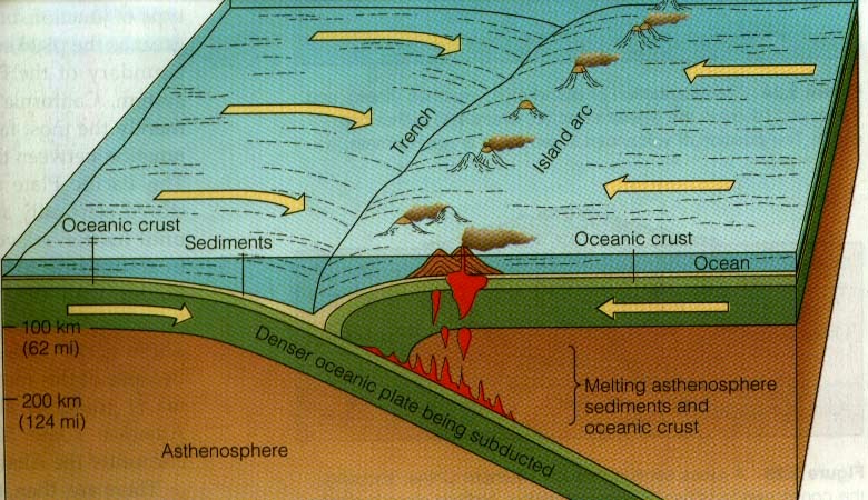
Grenada is a volcanic island, part of the Lesser Antilles island arc in the Caribbean. It is located along the Lesser Antilles subduction zone where the oceanic crust of the South American plate is being subducted under the Caribbean plate. The tectonic activity is responsible for the formation of the island and its volcanoes. The two most important volcanoes are Mt. Saint Catherine and Mt Kick 'em Jenny. Mt. Saint Catherine is a currently dormant stratovolcano and the highest point of the island. Mt Kick 'em Jenny is an active submarine volcano located about 8 km north of Grenada. Grenada has a mixed topography of high mountains and low valleys. These valleys contain rivers that flow out in a radial drainage pattern. 

Photo taken in December 2013 during my cruise to the Caribbean. In the image you can see some of Grenada's geographical features. 


10,000 years from now

10,000 years from now Grenada will be quite different. Due to climate change, sea levels have been rising about .13 in (3.2 mm) per year. Assuming that this continues, sea levels will be 108.3 ft. (32 m) higher in 10,000 years. Grenada's highest elevation is 840 ft., but otherwise varies from less than 300 ft. to 600 ft. about sea level. Due to this some of Grenada will remain above land, but most of its coastline will become submerged. Drowned river valleys or rias will become characteristic of Grenada since the rising seas level will flood and fill in the valleys located on the island. 

Retrieved from http://www.teara.govt.nz/en/photograph/13012/a-drowning-landscape
Image of a ria. Grenada may look more like this on a smaller scale in 10,000 years as sea levels rise.


1,000,000 years from now
In 1,000,000 years Grenada will change even more. All the Lesser Antilles including Grenada started out as submarine volcanoes. More submarine volcanoes will form around the area as the tectonic plates continue to move. Due to continued volcanic activity Mt. Kick 'em Jenny will be uplifted and eventually become connected to Grenada. The volcano has been known to erupt about every 10 years which means that it will erupt about 100,000 times in the next million years if it continues to be active. Each eruption forces the volcano more and more to the surface expanding it. Kick 'em Jenny may become connected to the rest of Grenada over time.
Due to the pattern of glacial and interglacial periods, sea levels will fall again exposing this formed land between Grenada and the currently submarine volcano. 


Retrieved from http://en.wikipedia.org/wiki/Kick_%27em_Jenny
Image showing depth of Mt. Kick 'em Jenny, 8 km of the coast of Grenada. 


100,000,000 years from now

For the next 100 million years the plates will continue moving resulting in continental drift. Even relatively small land masses like Grenada will be affected. The rate of subduction in the Lesser Antilles island arc is Caribbean is about 2 cm per year. In 100 million years it will have been subducted 2,000 km. This along with the movement of the other plates will eventually create another super continent like Pangaea. Due to continental drift these super continents form every few hundred million years and then break up again. In this next scenario the Caribbean Sea will shrink as the plates move west setting the Islands on a collision course with the main land. In this scenario Grenada will also move closer to the continent as the Caribbean Sea closes and the Atlantic Ocean expands. 

Retrieved from http://earthdharma.org/2010/01/
Map of tectonic processes in the Lesser Antilles including tectonic plate boundaries, rates of movement and active volcanoes.


Reference:
http://ocean.nationalgeographic.com/ocean/critical-issues-sea-level-rise/
http://en.m.wikipedia.org/wiki/Geography_of_Grenada
http://www.uwiseismic.com/general.aspx?id=27     Mount kick em jenny 
http://www.renewton.plus.com/geology/talks/2012/Tale%20of%20two%20islands/index.htm
https://www.youtube.com/watch?v=uQ91AxUqHck 
http://www.geo.mtu.edu/~raman/papers2/WadgeGeolVol.pdf

Wednesday, November 12, 2014

Severe Weather and Storms


Grenada experiences various degrees of severe stormy weather due to its' tropical climate, which consists of a wet and dry season. Thunderstorms make up about 11 percent of the precipitation on the island and are more common in the warmer season. This is because, to form, thunderstorms require moisture and unstable warm air that can rise rapidly. Sea breezes and the mountainous terrain of the island contribute to the rising of warm air which is present during the warm season. The air then forms into towering cumulus clouds. As the storm matures it can produce hail, rain, lighting, wind and even tornadoes. 

Retrieved from https://weatherspark.com/averages/33721/St-George-s-Grenada-Grenada
Graphs showing the percentages of type of precipitation in Grenada during different seasons. Top: Warm season. Bottom: Cold Season.

On the more extreme end, Grenada experiences hurricanes. This is partially due to Grenada's latitude of 12 degrees north, which puts it in the "Hurricane Alley". The five factors needed for the formation of a hurricane are a strong Coriolis Effect, high sea surface temperature, few changes in wind speed and direction, lots of water vapor, and convergence. At 12 degrees north, the Coriolis Effect is strong enough for a hurricane. Grenada's average water temperature stays fairly warm year round, ranging from about 79 to 84 degrees Fahrenheit. The water's temperature begins to increase in June and is warmest in October, which corresponds with the Hurricane season that lasts from June to November. The warm water releases latent heat which fuels the hurricane. Water vapor comes from the tropical ocean surrounding Grenada. A hurricane can form when those factors are combined with a lack of wind shear and convergence.


Retrieved from http://www.standard.co.uk/news/standard-pictures/hurricane-ivan-7322515.html?action=gallery&ino=1
Image of Hurricane Ivan.

Hurricanes are destructive partially due to the tornadoes and strong winds, but storm surges are the most devastating. High winds create an abnormal rise in sea level that results in flooding. This contributes to property damage and death. In 2004, Hurricane Ivan killed 39 people and devastated 85% of the island, including wildlife and property. Due to this, Grenada's economy also suffered.

Retrieved from http://www.oocities.org/hurricanene/hurricaneivan.htm
Image showing some of the destruction post Hurricane Ivan.

Photo taken in December 2013 during my cruise to the Caribbean. This is Grenada almost ten years after the very devastating Hurricane Ivan. Most of the destruction has been repaired except for a few building like the church seen on the left.


References:
http://en.wikipedia.org/wiki/Hurricane_Alley
http://www.worldtravelguide.net/grenada/weather-climate-geography
http://en.wikipedia.org/wiki/Geography_of_Grenada
https://weatherspark.com/averages/33721/St-George-s-Grenada-Grenada
http://www.un.org/events/tenstories/06/story.asp?storyID=1700 - hurricanes
http://en.wikipedia.org/wiki/Trade_wind
http://www.weather-and-climate.com/average-monthly-Rainfall-Temperature-Sunshine-fahrenheit,Grenada,Grenada
http://gocaribbean.about.com/od/beforeyougo/f/FAQCaribbeanhurricanes.htm
http://en.wikipedia.org/wiki/Hurricane_Ivan

Sunday, October 12, 2014

Hydrology in Grenada: Water is Fun, but Not Always

Grenada has many streams and rivers flowing through low valleys. These streams are part of a system of drainage basins divided by watersheds. A drainage basin is an area drained by a stream and its tributaries. The watersheds represent all the tributaries that run to a location along the stream channel. Grenada is split up into 71 watersheds. 


Retrieved from http://projects.inweh.unu.edu/inweh/display.php?ID=5618. Image showing locations of Grenada's watersheds. 
Due to its volcanic origins and mountainous terrain, some drainage patterns in Grenada are radial. The rivers and streams flow from a central high point, one of the volcanoes or mountains. Some places have a dendritic drainage pattern. The many streams join together in the tributaries of a main river, similar to the way twigs are attached to the branches of a tree. 

Retrieved from http://projects.inweh.unu.edu/inweh/display.php?ID=5618.
Image showing a high density of radial and dendritic drainage patterns within the watersheds in Grenada. 


Photo of Grenada taken during my cruise in December 2013. High points like the mountains in the background, would be a source of radial drainage patterns.

Grenada is a tropical island subject to heavy rainfall. It also has low soil permeability which means that water cannot move well through the pores. In some areas, the amount of water from rainfall exceeds the infiltration capacity. That is, how much water can move into the layers of soil. This results in overland flow, which is when water flows over the surface, usually towards a river. In Grenada, this process is responsible for the beautiful waterfalls that are located throughout the island. These waterfalls are a popular tourist destination, making them important to the islands economy, since tourism is one of the main industries. 

Retrieved from http://www.grenadagrenadines.com/explore/attractions/waterfalls/.
Annandale Waterfalls located in St. George, Grenada.

Retrieved from http://www.weather-and-climate.com/average-monthly-Rainfall-Temperature-Sunshine,Grenada,Grenada
Graph showing average monthly precipitation over the year in Grenada.


The characteristics of the island make it prone to flooding and flash floods. The high precipitation and the low soil permeability results in the rapid rise of water in the rivers. This combined with the high density drainage patterns causes a large amount of water to overflow into lower areas.

Retrieved from http://www.weefmgrenada.com/article.php?newstype=1&newsid=2535
Image shows flooded area in Grenada. The result of heavy rainfall.  

Floods can interfere greatly in the lives of the islands inhabitants. After a flood in 2011, businesses were closed, due to downed power lines. People can find themselves having to evacuate due to flood warnings. The floods have the potential to be devastatingly destructive to lives and property in Grenada.


References
https://www.oas.org/dsd/publications/Unit/oea51e/ch06.htm
http://en.wikipedia.org/wiki/Flash_flood
http://projects.inweh.unu.edu/inweh/display.php?ID=5618
http://www.weather-and-climate.com/average-monthly-Rainfall-Temperature-Sunshine,Grenada,Grenada
http://www.physicalgeography.net/fundamentals/10aa.html
http://en.wikipedia.org/wiki/Drainage_system_(geomorphology)
http://www.grenadagrenadines.com/explore/attractions/waterfalls/
http://www.weefmgrenada.com/article.php?newstype=1&newsid=2535

Monday, September 15, 2014

The Story of a Volcanic Island in a Subduction Zone

Grenada is part of the Lesser Antilles volcanic island arc. It has a mountainous interior with a mixed topography of high peaks and deep, narrow valleys. 
Photo taken December 2013 during my cruise to the Caribbean. In the image you can see the mountainous landscape of Grenada.

Today Grenada looks like the above image, but how did it come to be?

About two million years ago, Grenada was a submarine volcano located along what is now known as the Lesser Antilles subduction zone. A subduction zone is a convergent boundary between two tectonic plates where the more dense plate is subducted, or sinks, under the less dense plate. In the Lesser Antilles subduction zone, the oceanic crust of the South American Plate is being subducted under the oceanic crust of the Caribbean Plate. As the South American Plate is subducted, it losses volatile materials that partially melt the mantle of the overriding plate. This generates magma that extrudes through the lithosphere of the Caribbean Plate because it is less dense, resulting in volcanic eruptions. 

This ongoing process created a chain of volcanic islands, including Grenada, called the Lesser Antilles island arc.

Example image of a subduction zone forming an island arc.
http://www.london-oratory.org/chemistry_folder/Revision/Earth&Rocks/New/student%20workbook%203.htm


Map of the Lesser Antilles showing Grenada as part of the island arc. 
http://whatscookinginyourworld.blogspot.com/2010/05/day-15-barbados-fried-grouper-with-cou.htm


There are two active volcanoes of note in Grenada that are part of the volcanic chain.

Image showing where Kick 'em Jenny and Mount Saint Catherine are located in the Lesser Antilles volcanic arc.
http://www.thedominican.net/articles/platpays.htm


Kick 'em Jenny is a submarine volcano located 8 km off the coast of Grenada. It is the most active volcano in the Lesser Antilles, erupting about every ten years. For now, there isn't much immediate danger from the volcano since it is too deep for eruptions to reach the surface. However, due to its rate of ascension it may rise above sea level in the next 100 years or so.

Underwater image of Kick 'em Jenny
https://www.youtube.com/watch?v=6EEj0Maq4q0

Mount Saint Catherine is the youngest of the five volcanoes in Grenada. It is a stratovolcano, so called because it is made up of different layers, or strata. This type of volcano is common in subduction zones. It has not erupted in recorded history, but there are signs of volcanic activity in that area from as long ago as two million years, during the Pliocene Period. There is a slim chance that the volcano may erupt, but for now it poses little threat to the inhabitants of the island.

Panorama image of Mount Saint Catherine
http://www.panoramio.com/photo/85189254


References:
http://en.wikipedia.org/wiki/Caribbean_Plate
http://en.wikipedia.org/wiki/Subduction
https://www.youtube.com/watch?v=6EEj0Maq4q0
http://en.wikipedia.org/wiki/Lesser_Antilles
http://en.wikipedia.org/wiki/Grenada
http://www.renewton.plus.com/geology/talks/2012/Tale%20of%20two%20islands/index.htm
http://en.wikipedia.org/wiki/History_of_Grenada
http://en.wikipedia.org/wiki/Island_arc
https://www.oas.org/dsd/publications/Unit/oea51e/ch06.htm


Saturday, August 30, 2014

Introduction: The Isle of Spice


Hi, my name is Veronica Scherbak. I am a junior and a Psychology major at the University of Colorado Denver. Before you ask, no, I cannot read minds, at least not without an MEG.

Since I was four, I have been taking cruises with my family. In December 2013, we took a two week southern Caribbean cruise. During the trip, the cruise ship stopped at a relatively small island, located at the southeastern end of the Caribbean, called Grenada. Also known as "the Isle of Spice", due to it being one of the world's largest exporters of nutmeg and mace crops, it is a beautiful place full of picturesque scenery, sandy beaches and historic sites. I have been cruising since I was four and have gone on many cruises, the majority in the Caribbean. Over all those years, this was the first time one had made port in Grenada. Over the few hours that I spent there, I fell in love with it. I consider it one of my favorite islands of the Caribbean and I would love to go their again! For now, I will satisfy myself by learning more about the island's rich and varied geography. 

I hope you enjoy going along with me on this adventure, across what I consider to be one of the loveliest and most fascinating places in the Caribbean!


This is a photo taken December 2013 from the top of Fort George, one of the historic sites, during my stay in Grenada. In the distance, you can see Mount St. Catherine, the tallest mountain and youngest volcano on the island. Closer up, you get a view of some of the capitol, St. George, and the inner harbor. Also, you get a glimpse of the gorgeous flora found in Grenada.


References:
http://www.grenadagrenadines.com/about-the-islands/discover-grenada/
http://www.peakbagger.com/peak.aspx?pid=8268
http://www.grenadaexplorer.com/tip/fort_george/